Beschrijuinge vande vermaerde stroemen, tulie ende...


 Maps, plans and nautical charts
Beschrijuinge vande vermaerde stroemen, tulie ende Tmaersdiep... (1853)
Maps, plans and nautical charts
Beschrijuinge vande vermaerde stroemen, tulie ende Tmaersdiep... (1853)
 Disponible Holdings
 Section: Maps, plans and nautical charts
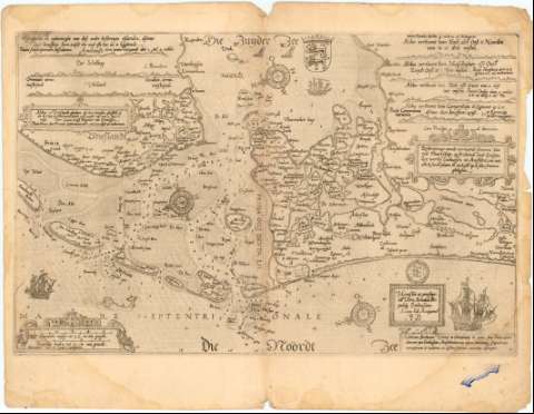
Title: Beschrijuinge vande vermaerde stroemen, tulie ende Tmaersdiep... / Lucas Ians Wagenaer van Enchurisen
Material or type of resouce Area: Escala [ca. 1:400000], 5 Spaensche mijlen tot 17 1/2 in een graedt [= 8 cm]
Publication: [Frisia ?] : Lucas Ioes Aurigacius, 1853
Physical description: 1 carta ; 41x53 cm
Notes: Presenta además 7 perfiles
Pertenece al Atlas Maritimo 'Die Spiegheld der Zeevaerdt'
Orientado con lis en rosa de 32 vientos prolongados
Indica veriles, bajos, fondeaderos y sondas batimétricas
Señala núcleos de población mediante edificios de perfil
Título enmarcado en cartela. Representación de barcos y monstruos en el mar
Procede de la 'Colección Rico y Sinobas'
Materia / lugar / evento: Cartas náuticas
1853
Other authors: Waghenaer, Lucas Jansz (ca. 1533-1606)
UDC: 912:551.46(492-328 Frisia)'1583'
492-328 Frisia
Type of publication:
Maps
Rights:
Préstamo:
Disponible
