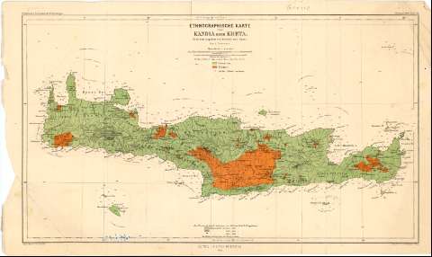
Etnographische Karte von Kandia oder Kreta


 Disponible Holdings
 Section: Maps, plans and nautical charts
Uniform title: CRETA (Grecia) (Isla). Etnografía. 1:650000 (1866)
Title: Etnographische Karte von Kandia oder Kreta / Nach den Angaben von Pashley und Spratt ; Von A. Petermann ; Lith. Anst. von C. Helfarth ; Gezeichnet v. Habenicht
Material or type of resouce Area: Escala 1:650000 ; [proyec. cónica] (E23°30'-E26°20'/N36°00'-N34°40')
Publication: Gotha : Justus Perthes, 1866
Physical description: 1 mapa : col. ; 27,5x46,5 cm
Notes: Pertenece a : 'Petermann's Geographische Mittheilungen'
Escalas gráficas de 5 millas alemanas [= 5,6 cm], 15 millas maritimas inglesas [= 4,2 cm]. Coordenadas referidas, al parecer, al meridiano de Paris (E21°02'-E24°05'/N36°00'-N34°30'). Red geográfica de 1° en 1°
Relieve representado por curvas de configuración y puntos acotados. Sondas batimétricas
Relación de la distribución de griegos y turcos, las colonias arabes y la altimetria indicados por clave cromática
Materia / lugar / evento: Etnografía
1866
Other authors: Spratt, Thomas Abel Bremage
Petermann, Augustus Herman
Hellfarth, C
Habenicht, Hermann
Perthes, Justus, 1749-1816
UDC: 912:391.397(495-328 Creta)'1866'
495-328 Creta
Type of publication:
 Maps
Maps
Rights:
Préstamo:
Disponible
