New Map of Greece exhibiting the provinces governed by...


 Maps, plans and nautical charts
New Map of Greece exhibiting the provinces governed by Ali Pacha and his children, viz South Albania, thessaly, part... (1817)
Maps, plans and nautical charts
New Map of Greece exhibiting the provinces governed by Ali Pacha and his children, viz South Albania, thessaly, part... (1817)
 Disponible Holdings
 Section: Maps, plans and nautical charts
Uniform title: Grecia. Mapas generales. 1:540000 (1817)
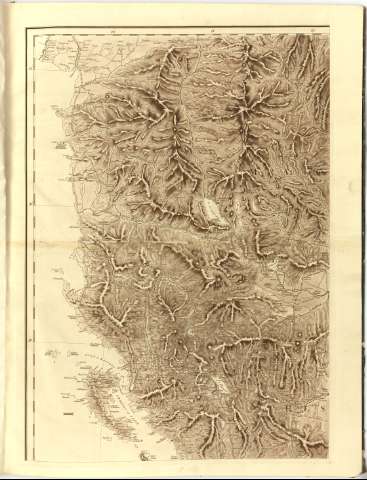
Title: New Map of Greece exhibiting the provinces governed by Ali Pacha and his children, viz South Albania, thessaly, part of Macedonia, Livadid, and the Morea < A / Genl. Gillaume de Vaudencourt
Material or type of resouce Area: Escala [ca. 1:540000], 60 British Statute Miles [= 18 cm] ; [proyec. cónica] (E19°30'-E24°30'/N42°10'-N36°05')
Publication: London : Published by J. Cary, 1817
Physical description: 1 mapa en 4 h. : col. ; h. de 73x59 cm
Notes: Escalas gráficas de 20 leguas comunes de Francia, 45 millas italianas geográficas, 60 millas griegas, 50 millas romanas de 8 estadios, olímpicos y 12 horas de ruta. Red geográfica de 1° en 1°
Relieve representado por sombreado
Tabla de signos convencionales para indicar núcleos de población de distinta categoria, caminos, castillos y distritos
Título enmarcado en cartela circular
Encuadernado en cartone verde con lomo en piel
Other authors: Vaudencourt, Guillaume de
Cary, John, elder
UDC: 912(495)'1817'
(496.5-13)
Type of publication:
Maps
Rights:
Préstamo:
Disponible
