A Map of the Seven United Provinces with the land of...


 Maps, plans and nautical charts
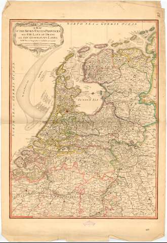
A Map of the Seven United Provinces with the land of Drent and the Generality Lands (1794)
Maps, plans and nautical charts
A Map of the Seven United Provinces with the land of Drent and the Generality Lands (1794)
 Disponible Holdings
 Section: Maps, plans and nautical charts
Uniform title: PAISES BAJOS. Mapas generales. 1794. 1:520000 (1789)
Title: A Map of the Seven United Provinces with the land of Drent and the Generality Lands / by W. Faden...
Edición: 2nd. Ed.
Material or type of resouce Area: Escala [ca. 1:520000], 40 British Statute Miles [= 12, 5 cm] ; [proyec. cónica]
Publication: London : Published by W. Faden Charing Cross, 1794
Physical description: 1 mapa : col. ; 72x54 cm en h. de 87x60 cm, pleg. en 44x60 cm
Notes: Escalas gráficas de 6 'dutch and german miles' [= 8,8 cm], 6 'nautic Leagues' [= 6,5 cm]. Coordenadas referidas al meridiano de Londres (E3°30'-E7°15'/N53°50'-N49°35'). Red geográfica de 1° en 1°
Relieve de perfil y representado por normales
Indica nucleos de población, masas forestales y los límites de las divisiones administrativas en color
Título y escalas enmarcados en cartela
Procede de la 'Colección Rico y Sinobas'
Materia / lugar / evento: Mapas generales
1789
Other authors: Faden, William, 1749-1836
UDC: 912(492)'1787'
492
Type of publication:
Maps
Rights:
Préstamo:
Disponible
