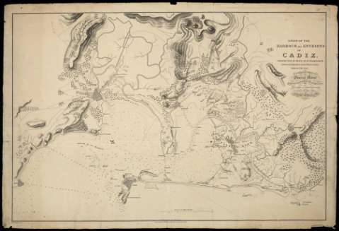
A Plan of the Harbour and Environs of Cadiz : Constructed...


 Maps, plans and nautical charts
A Plan of the Harbour and Environs of Cadiz : Constructed by means of an examination of the bist Authorities, and... (1811)
Maps, plans and nautical charts
A Plan of the Harbour and Environs of Cadiz : Constructed by means of an examination of the bist Authorities, and... (1811)
 Disponible Holdings
 Section: Maps, plans and nautical charts
Uniform title: Cádiz (Provincia). Cartas náuticas. 1:26.400 (1811)
Title: A Plan of the Harbour and Environs of Cadiz : Constructed by means of an examination of the bist Authorities, and of Observations made on the spot : Is with Permifsion Dedicated to General Morse, Inspector General of Fortifications / by George Landmann, Captain in the Corps Royal Ingineers ; Engraved by Edwd. Jones
Material or type of resouce Area: Escala [ca. 1:26.400]. tres Millas marítimas [= 15,8 cm]
Publication: London : Published...A. Arrowsmith 10 Soho Square for the Author, 1811
Physical description: 1 carta náutica ; 68 x 101 cm
Content type: Imagen cartográfica
Media type: computadora
Carrier type: recurso en línea
Notes: Escala numérica 1:35.010, manuscrita a lápiz con posterioridad. Orientada con lis
Relieve representado por normales
Indica veriles, bajos y fondeaderos
Señala la vegetación
Al verso: "Para D. Tomás Cortes"
Materia / lugar / evento: Cartas náuticas
Vegetación
Puertos
Guerras de independencia
1811
Cádiz (Provincia)
Andalucía
España
Other authors: Landman, George
Arrowsmith, Aaron, 1750-1823
Jones, Edward
UDC: (460.355)
Type of publication:
Maps
Rights:
Préstamo:
Disponible
