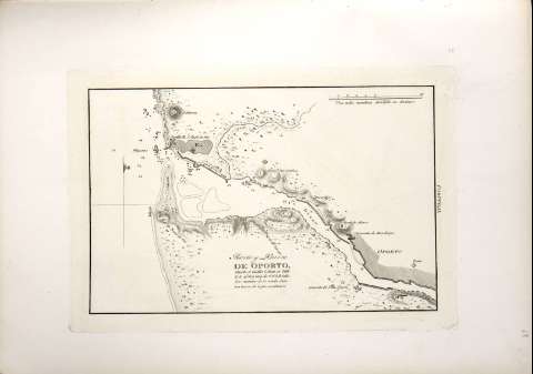
Puerto y Barra de Oporto
Section: Maps, plans and nautical charts
Uniform title: Oporto (Puerto). Cartas náuticas. 1813. Español. 1:27.000
Title: Puerto y Barra de Oporto / [Dirección Hidrográfica]
Material or type of resouce Area: Escala [ca.1:27.000]
Physical description: 1 carta náutica ; 18 x 26 cm
Content type: Imagen cartográfica
Media type: computadora
Carrier type: recurso en línea
Notes: Mención de responsabilidad y pié de imprenta tomados de la portada del atlas
Escala gráfica de una milla marítima [=6,9 cm]. Coordenadas del castillo San Juan (O 2°19'/N 41°09')
Orientado con media lis en nudo de cuatro rumbos
Relieve representado por normales
Indica sondas batimétricas, veriles y bajos
Clave hidrográfica para determinar la calidad del fondo
Señala la situación de la ciudad de Oporto y de las fortificaciones y conventos de sus alrededores
En el margen derecho : "Portugal"
Other titles: En: Portulano de la Península de España : Cuaderno 4. Costa de Portugal. - [Cádiz] : [Dirección de Hidrografía], [1813]
Materia / lugar / evento: España - Historia - 1808-1814 (Guerra de la Independencia)
Portugal
Genre / form: Cartas náuticas
Other authors: España. Dirección de Hidrografía
UDC: 912:551.46](469.121:26.04)"1813"
(469.121:26.04 Oporto)
Type of publication:
![]() Maps
Maps
Préstamo:
![]() Disponible
Disponible


