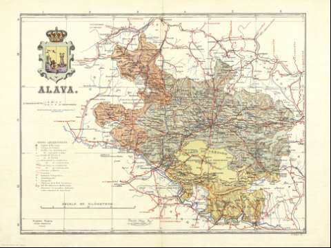
Alava


Section: Maps, plans and nautical charts
Uniform title: Álava. Mapas generales. 1913-1919. Español. 1:285.714
Title: Alava / Benito Chias Ingº. ; J. Soler Gº
Material or type of resouce Area: Escala [ca. 1:285.714]
Publication: Barcelona : Alberto Martín, [1913-1919]
Physical description: 1 mapa : col. ; 39 x 52 cm, pleg. en 39 x 26 cm
Content type: Imagen cartográfica
Media type: computadora
Carrier type: recurso en línea
Notes: Coordenadas referidas al meridiano de Madrid (E 0 00'-E 1 30'/N 43 6'-N 42 08'). Figuran además latitud y longitud de la capital de provincia y coordenadas horarias
Relieve representado por normales
Leyenda de símbolos
Ilustrado con escudo provincial
Figura impresa la firma del autor
Al verso, índice de ayuntamientos, nivelaciones y vértices geodésicos de primer orden
Other titles: En: España regional. - Barcelona : Alberto Martín, [1913-1919]
Materia / lugar / evento: Mapas generales
Partidos judiciales
Redes de transporte
Telegrafía
Diócesis
Nivelaciones
S.XX
País Vasco
Other authors: Chías y Carbó, Benito. España regional. Cartas corográficas. Español
Soler, J
Editorial Alberto Martín
UDC: 912:[262.3+654.1+528.37/.38](460.156-37)"1913/1919"
(460.156 Álava)
Type of publication:
 Maps
Maps
Rights:
Préstamo:
 Disponible
