Iceland and the Faeroe islands from the Danish Survey...


 Maps, plans and nautical charts
Iceland and the Faeroe islands from the Danish Survey 1845 : With additions from french charts 1859 (1860)
Maps, plans and nautical charts
Iceland and the Faeroe islands from the Danish Survey 1845 : With additions from french charts 1859 (1860)
 Disponible Holdings
 Section: Maps, plans and nautical charts
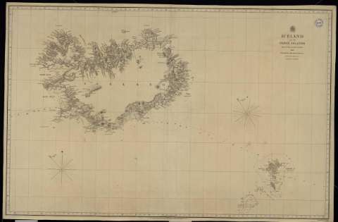
Title: Iceland and the Faeroe islands from the Danish Survey 1845 : With additions from french charts 1859 / Engraved by J. & C. Walker
Material or type of resouce Area: Escala [ca. 1:1.234.567]
Publication: London : Published at the Admiralty, 1860
Physical description: 1 carta náutica : papel entelado ; 64 x 98 cm
Content type: Imagen cartográfica
Media type: computadora
Carrier type: recurso en línea
Notes: Meridiano de Greenwich
Sello: Hydrographic Office
Nº H. O.: 2740
Genre / form: Cartas náuticas
Other authors: España. Dirección de Hidrografía, productor
UDC: (261.1)
Type of publication:
Maps
Rights:
Real Instituto y Observatorio de la Armada
Collection: PROA — Location: PL — Call number: M/0098 — Nº de registro: 98 — Código de barras: 9600740 — Notes: Bueno
Préstamo:
Disponible

© Ministerio de Defensa de España
P. de la Castellana, 109 28071 Madrid.
Tlf: (34) 91 395 50 00
Email: patrimonio.cultural@oc.mde.es