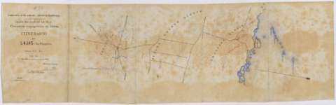
Itinerario de Lajas á La Parguera : 91/² kms.


Section: Maps, plans and nautical charts
Uniform title: Puerto Rico. Itinerarios topográficos. 1:20000 (1888?)
Title: Itinerario de Lajas á La Parguera : 91/² kms. [Mapa] / Cuerpo de E.M. del Ejército, Sección de Puerto Rico, Comisión Topográfica de 1888 ; El Comte. Capitán José de Elola y Gutiérrez
Material or type of resouce Area: Escala 1:20000
Physical description: 1 map. : ms., col., realizado sobre tela para planos ; 31'2 x 10⁴'6 cm, pleg. en 31'2 x 21'0 cm o menos + 1 carpetilla y memoria
Content type: Imagen cartográfica
Media type: computadora
Carrier type: recurso en línea
Notes: Itinerario realizado para la formación del Mapa Militar de la Isla
Indica hidrografía, orografía, barrios, costas, representaciones simplificadas de poblaciones, fincas rústicas y ramales que parten del camino, señalando el lugar al que se dirigen
Relieve representado mediante curvas de nivel equidistantes 20 m. y puntos acotados
Acompañado de Memoria explicativa, observaciones y relación de puntos notables del camino
Dibujado a tinta marrón, roja, azul y negra
Firmado y rubricado por el autor
Materia / lugar / evento: Itinerarios topográficos
1888
Santa Isabel de las Lajas
Parguera
Other authors: Elola y Gutiérrez, José de, 1859-1933
Puerto Rico (Capitanía General). Comisión Topográfica de 1888
UDC: 912:528.42]333.5(729.5)"1888"
729.5
Type of publication:
 Maps
Maps
Rights:
Préstamo:
 Disponible
