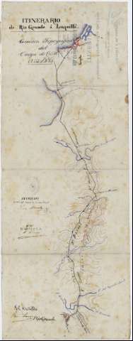
Itinerario de Rio Grande a Luquillo


Section: Maps, plans and nautical charts
Uniform title: Puerto Rico. Itinerarios topográficos. 1:20000 (1885)
Title: Itinerario de Rio Grande a Luquillo [Mapa] / Comisión topográfica del Cuerpo de E.M. Año 1885 ; Francisco Larrea
Material or type of resouce Area: Escala 1:20000
Physical description: 1 map. : ms., col., en tela para planos ; 73'2 x 27'7 cm, pleg. en 27'5 x 18'7 cm + 1 carpetilla y 1 memoria
Content type: Imagen cartográfica
Media type: computadora
Carrier type: recurso en línea
Notes: Itinerario realizado para la formación del Mapa Militar de la Isla
Indica orografía, hidrografía y barrios que parten del camino carretero
Manuscrito firmado y rubricado por el autor, con firmas de conformidad del Tte. Corl. Jefe de la Seccn. Topoga., Luis Moncada, y del Corl. Jefe de E.M
Relieve representado por curvas de nivel, equidistancia : 20 m
Delineado con tinta roja, azul y negra
Figura el sello del Cuerpo de Estado Mayor del Ejército, Sección de Puerto Rico
Acompañado de memoria explicativa del recorrido, plegada junto con el mapa en carpetilla
Representación simplificada de las poblaciones de Rio Grande y Luquillo
Materia / lugar / evento: Itinerarios topográficos
Río Grande (Puerto Rico)
Luquillo
Other authors: Larrea y Liso, Francisco, 1855-1913
Puerto Rico (Capitanía General). Comisión Topográfica de 1885
UDC: 912:528.42(729.5)"1885"
729.5
Type of publication:
 Maps
Maps
Rights:
Préstamo:
 Disponible
