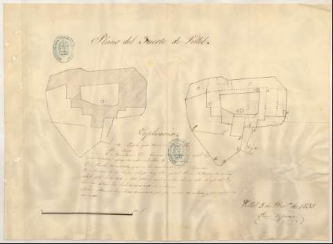
Plano del Fuerte de Villel


Section: Maps, plans and nautical charts
Uniform title: VILLEL (Teruel). Fortalezas militares. 1:242 (1839)
Title: Plano del Fuerte de Villel / Franco. Espinosa
Material or type of resouce Area: Escala [ca. 1:242], 100 ps. [= 11'5 cm]
Publication: 1839 dic. 5
Physical description: 1 plano : ms. ; 30'3x41'7 cm
Content type: Imagen cartográfica
Media type: computadora
Carrier type: recurso en línea
Notes: Manuscrito firmado, rubricado y fechado en Villel
Manuscrito a plumilla en tinta negra
Explicación de las claves alfabéticas
Aparecen 2 plantas
Reproducción digital. Madrid : Ministerio de Defensa. Archivo General Militar de Madrid
Materia / lugar / evento: Teruel (Provincia)
Other authors: Espinosa, Francisco
UDC: 465.23 Villel
Type of publication:
 Maps
Maps
Rights:
Préstamo:
 Disponible
