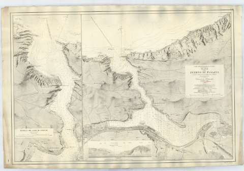
Plano del Puerto de Pasajes


Section: Maps, plans and nautical charts
Uniform title: PASAJES (Guipúzcoa). Cartas náuticas. 1907. 1:5.000 (1898)
Title: Plano del Puerto de Pasajes / Levantado en 1898 por la Comision Hidrográfica a bordo del vapor de guerra Urania ; L. Galvan los grabó, S. Bregante y Ma. go. la letra
Edición: Ed. corr
Material or type of resouce Area: Escala 1:5.000
Publication: Madrid : Dirección de Hidrografía, 1907
Physical description: 1 carta nautica : col. ; 70x104 cm
Content type: Imagen cartográfica
Media type: computadora
Carrier type: recurso en línea
Series: (Costa Septentrional de España ; 200)
Notes: Edición de 1901 corregida en 1907
Orientado con estrella, N. al NO. y N. magnético
Relieve representado por normales y curvas de nivel
Batimetría. Veriles
Indicados los faros en color amarillo
Notas: 'Las sondas y elevaciones estan expresadas en metros..., Variacion de la aguja para 1901, Decremento ánuo 6' proximamente'. Indicada la composición de los fondos marinos
Localización geográfica del Faro de Pasajes según el meridiano de Sn. Fernando
Figura en el margen inferior una vista de Pasajes
Aparece en el ángulo inferior derecho: 'Precio 3 pesetas'
Inserta: Detalle del Canal de Entrada. Escala 1:2.500. - 63x30 cm
Reproducción digital. Madrid : Ministerio de Defensa. Archivo General Militar de Madrid
Other authors: Galván, L
Bregante y Martínez, S
España. Comisión Hidrográfica
España. Dirección de Hidrografía
UDC: 466.2 Pasajes
Type of publication:
 Maps
Maps
Rights:
Préstamo:
 Disponible
