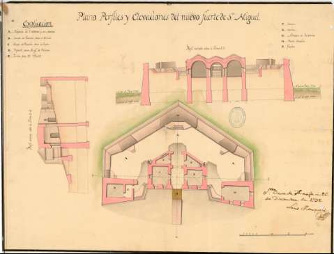
Plano Perfiles y Elevaciones del nuevo fuerte de Sn. Miguel


 Maps, plans and nautical charts
Plano Perfiles y Elevaciones del nuevo fuerte de Sn. Miguel (26 de Diciembre de 1792)
Maps, plans and nautical charts
Plano Perfiles y Elevaciones del nuevo fuerte de Sn. Miguel (26 de Diciembre de 1792)
 Disponible Holdings
 Section: Maps, plans and nautical charts
Uniform title: SANTA CRUZ DE TENERIFE (Santa Cruz de Tenerife) (Tenerife). Fuertes. Escala indeterminada (1792)
Title: Plano Perfiles y Elevaciones del nuevo fuerte de Sn. Miguel / Luis Marqueli
Material or type of resouce Area: Escala indeterminada
Publication: Santa Cruz de Tenerife, 26 de Diciembre de 1792
Physical description: 1 plano : ms., col. ; 57 x 43 cm
Content type: Imagen cartográfica
Media type: computadora
Carrier type: recurso en línea
Notes: Presenta la planta, 1 perfil y 1 alzado
Manuscrito firmado y rubricado por el autor
Manuscrito en tinta negra, coloreado varios colores
Relación de contenido en clave alfabética
Materia / lugar / evento: Fuertes
Fortificaciones
Proyectos
Perfiles
1792
Santa Cruz de Tenerife (Provincia)
Canarias
Other authors: Marqueli, Luis
Type of publication:
Maps
Rights:
Préstamo:
Disponible
