A Topographical Map of the Isle of Minorca Geometrically...


 Maps, plans and nautical charts
A Topographical Map of the Isle of Minorca Geometrically Surveyed by the Royal Engineers while it remained in the... (1780)
Maps, plans and nautical charts
A Topographical Map of the Isle of Minorca Geometrically Surveyed by the Royal Engineers while it remained in the... (1780)
 Disponible Holdings
 Section: Maps, plans and nautical charts
Uniform title: MENORCA (Baleares). Mapas topográficos (1780). Varias escalas
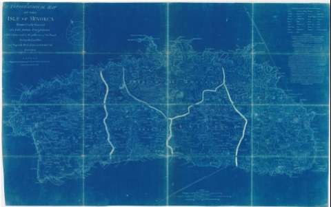
Title: A Topographical Map of the Isle of Minorca Geometrically Surveyed by the Royal Engineers while it remained in the possesion of the Freneh during the Last war / Digested by L.S. de la Rochette
Material or type of resouce Area: Varias escalas
Publication: London : Engraved and published by William Faden, 1780
Physical description: 1 mapa ; 95,5 x 60 cm
Content type: Imagen cartográfica
Media type: computadora
Carrier type: recurso en línea
Notes: Comprende la isla de Menorca
Orientado con nudo de rumbos y lis
Tabla de palabras en mallorquín y su traducción al inglés
Señala caminos e hidrografía
Figuran las defensas de la isla
Toponimia
Nota sobre la localización de las baterías y otras fortificaciones
Fotocopia en ferroprusiato
Materia / lugar / evento: Mapas topográficos
Caminos
Comunicaciones
1780
Baleares (Comunidad Autónoma)
Other authors: La Rochette, Louis Stanislas D'Arcy de
Type of publication:
Maps
Rights:
Préstamo:
Disponible
