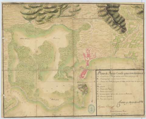
Plano de puerto Cavello y sus inmediaciones


Section: Maps, plans and nautical charts
Title: Plano de puerto Cavello y sus inmediaciones / Agustin Cramer
Material or type of resouce Area: Escala [ca. 1:8648], 600 varas castellanas [= 5,8 cm]
Publication: Caracas y Mayo 15 de 1778
Physical description: 1 plano : ms., col., montado sobre tela ; 45,3 x 56 cm
Content type: Imagen cartográfica
Media type: computadora
Carrier type: recurso en línea
Notes: Presenta el plano de la ciudad y de la fortificación de San Felipe
Manuscrito firmado y rubricado por el autor
Orientado con media lis
Relieve representado por sombreado
Indica sondas batimétricas
Manuscrito coloreado a la acuarela en varios colores
Relación de los principales puntos del plano indicados por clave alfabética
Señala los principales campos cultivados de la zona representada
Se dispone además del documento con sign. SH+6067/L-6/61, que muestra el mismo plano
Materia / lugar / evento: Planos de población
Mapas generales
Batimetría
Fortificaciones
Tierras de cultivo
1778
Carabobo
Other authors: Crame y Mañenas, Agustín
UDC: 872.39 Puerto Cabello
Type of publication:
 Maps
Maps
Rights:
Préstamo:
 Disponible
