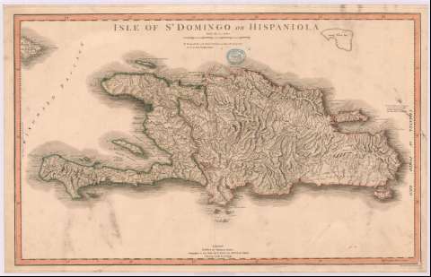
Isle of St. Domingo or Hispaniola


 Disponible Holdings
 Section: Maps, plans and nautical charts
Uniform title: SANTO DOMINGO (Isla). Mapas generales. 1796 (1796). 1:931028
Title: Isle of St. Domingo or Hispaniola / engraved by John Cooke, Hendon
Material or type of resouce Area: Escala [ca. 1:931028], 70 statute mile [= 12'1 cm]
Publication: London : published by William Faden, Geographer to the King and the H.R.H. the Prince of Wales, Charing Cross, Yany. [sic] 1st 1796
Physical description: 1 mapa : col., montado sobre tela ; 46 x 75 cm
Content type: Imagen cartográfica
Media type: computadora
Carrier type: recurso en línea
Notes: Coordenadas referidas al meridiano de Londres
Relieve por normales
Indica sondas batimétricas y veriles
En nota se explica que la parte española de la isla, se ha tomado del reconocimiento hecho en 1776 por José Solano
Límites de fronteras diferenciados por color
Materia / lugar / evento: Mapas generales
Divisiones administrativas
Batimetría
1776
1796
República Dominicana
Haití
Other authors: Cooke, John
Faden, William, 1749-1836
UDC: 729.3/.4
Type of publication:
 Maps
Maps
Rights:
Préstamo:
Disponible
