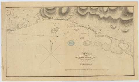
A Plan of the Anchorage at Morant Bay and the Coast from...


 Maps, plans and nautical charts
A Plan of the Anchorage at Morant Bay and the Coast from Belvedere Point to Fisherman's Bay (1793)
Maps, plans and nautical charts
A Plan of the Anchorage at Morant Bay and the Coast from Belvedere Point to Fisherman's Bay (1793)
 Disponible Holdings
 Section: Maps, plans and nautical charts
Title: A Plan of the Anchorage at Morant Bay and the Coast from Belvedere Point to Fisherman's Bay / Surveyed by J. Leard 1792 ; S.J. Neele sculpt
Material or type of resouce Area: Escala [ca. 1:14764], 2 statute miles [= 21'8 cm]
Publication: [London] : John Leard, 1793
Physical description: 1 carta náutica : Papel verjurado con marca de aguas: escudo ; 41 x 71 cm
Content type: Imagen cartográfica
Media type: computadora
Carrier type: recurso en línea
Notes: Orientado con lis en nudo de rumbos en el que se señala además, la variación magnética observada
Relieve por normales
Indica sondas batimétricas, así como las distintas líneas de derrota para arribar a la bahía
Toponimia costera de los principales accidentes geográficos y núcleos de población más significativos
Sello del depósito general topográfico de ingenieros
Other authors: Neele, Samuel John, 1758-1824
Leard, John
UDC: 729.2-12
Type of publication:
Maps
Rights:
Préstamo:
Disponible
