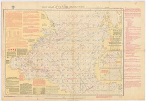
Pilot chart of the North Atlantic Ocean


 Disponible Holdings
 Section: Maps, plans and nautical charts
Uniform title: ATLANTICO (Océano). N. Cartas náuticas. 1:1322751 (1933)
Title: Pilot chart of the North Atlantic Ocean
Material or type of resouce Area: Escala [ca. 1:1.322.751]
Publication: Washington, D. C. : Hydrographic Office, 1933
Physical description: 1 carta aérea : col. ; 58 x 80 cm. en h. 66 x 96 cm
Content type: Imagen cartográfica
Media type: computadora
Carrier type: recurso en línea
Notes: Indica corrientes de vientos, rutas aéreas e isobaras
Orientado con rosa de los vientos
Clave de símbolos para identificar las condiciones atmosféricas
Incluye notas explicativas tanto dentro como fuera delmapa
Inserta: Mapa de isobaras ; Mapa de porcentage de lluvia
Materia / lugar / evento: Cartas aeronáuticas
Vientos
Isóbaras
Costas
Mares
Climatología
1933
América del Norte
Europa Occidental
África
Océano Atlántico Norte
Other authors: Estados Unidos. Hydrographic Office
UDC: 7
4
6
261
Type of publication:
 Maps
Maps
Rights:
Préstamo:
Disponible
