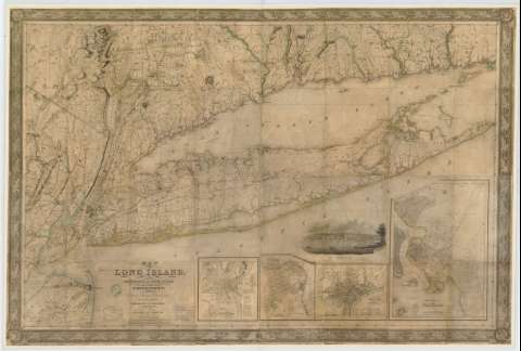
Map of Long Island whit the Environs of New- York and the...


 Maps, plans and nautical charts
Map of Long Island whit the Environs of New- York and the southern part of Connecticut (1837)
Maps, plans and nautical charts
Map of Long Island whit the Environs of New- York and the southern part of Connecticut (1837)
 Disponible Holdings
 Section: Maps, plans and nautical charts
Title: Map of Long Island whit the Environs of New- York and the southern part of Connecticut / Compiled from Various surveys documents by J. Calvin Smith
Material or type of resouce Area: Escala [ca. 1:144.986]. Scale of 2 y medio miles to aninch
Publication: New York : J. H. Colton & Company, 1837
Physical description: 1 mapa : col., montado sobre tela ; 95 x 141 cm
Content type: Imagen cartográfica
Media type: computadora
Carrier type: recurso en línea
Notes: Clave simbólica para indicar las categoría de los caminos y medios de transporte
Cenefa decorativa a lo largo de los márgenes
Incluye una vista de New Brigthon
Materia / lugar / evento: Mapas generales
Planos de población
Núcleos de población
Islas
Costas
1837
Nueva York
Estados Unidos
Other authors: Calvin, Jean
UDC: 747
Type of publication:
Maps
Rights:
Préstamo:
Disponible
