Topographical map of the Approaches and defences of...


 Maps, plans and nautical charts
Topographical map of the Approaches and defences of Knoxville E. Tennessee showing the positions occuped by the... (1864)
Maps, plans and nautical charts
Topographical map of the Approaches and defences of Knoxville E. Tennessee showing the positions occuped by the... (1864)
 Disponible Holdings
 Section: Maps, plans and nautical charts
Uniform title: KNOXVILLE (Estados Unidos) (Tennessee). Estrategia militar. 1864 (1863-1864). 1:9934
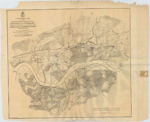
Title: Topographical map of the Approaches and defences of Knoxville E. Tennessee showing the positions occuped by the United States & Confederate Forces during the siege / Surveyed by direction of Capt. O. M. Poe Chf. Engr. Dept. of the Ohio during Dec. Jan, and Feb. 1863-4
Material or type of resouce Area: Escala [ca. 1:9934], 1760 yards [= 16'2 cm]
Publication: [Washington D. C.] : Published by authority of the Hon. Secretary ofWar in the office of the Chief of Engineers U.S. Army, 1864
Physical description: 1 mapa : col. ; 66 x 75 cm
Content type: Imagen cartográfica
Media type: computadora
Carrier type: recurso en línea
Notes: Comprende los alrededores de la ciudad de Knoxville, en el estado norteamericano de Tennessee
Escala gráfica también expresada en 1 milla legal [= 16'2 cm]. Orientado con media flecha
Relieve por curvas de nivel y puntos acotados
Clave cromátiva para diferenciar las operaciones militares y los movimientos realizados por los ejércitos federel y confederado
Materia / lugar / evento: Estrategia militar
Mapas topográficos
1864
Other authors: Poe, O. M
Estados Unidos. Army. Office of the Chief of Engineers
UDC: 768 Knoxville
Type of publication:
Maps
Rights:
Préstamo:
Disponible
