Chart of the West Indies and Spanish Dominions in North...


 Maps, plans and nautical charts
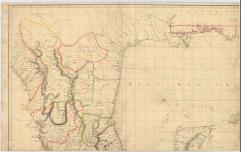
Chart of the West Indies and Spanish Dominions in North America (1803)
Maps, plans and nautical charts
Chart of the West Indies and Spanish Dominions in North America (1803)
 Disponible Holdings
 Section: Maps, plans and nautical charts
Title: Chart of the West Indies and Spanish Dominions in North America / By A. Arrowsmith, 1803
Material or type of resouce Area: [ca. 1:2469135-1:2777777]
Publication: London : Published by A. Arrowsmith, 1803
Physical description: 1 mapa en 4 h. : col., montado sobre tela ; en h. de 60 x 95 cm o menos
Content type: Imagen cartográfica
Media type: computadora
Carrier type: recurso en línea
Notes: Comprende desde la parte meridional del estado norteamericano de Florida hasta la parte septentrional de América del Sur
Escala hallada a partir de 1° de latitud [= 4'5 cm] y [= 4'0 cm]. Proyec. Mercator. Coordenadas referidas a un meridiano que no se especifica. Orientado con nudos de treinta y dos rumbos
Relieve representado por normales
Indica sondas batimétricas y fondeaderos
Límites administrativos diferenciados por color
En nota se informa sobre las características del área representada
Documento incompleto. Falta una de sus hojas
Materia / lugar / evento: Mapas generales
Divisiones administrativas
1803
México
América Central
Other authors: Arrowsmith, Aaron, 1750-1823
UDC: 7
72
Type of publication:
Maps
Rights:
Préstamo:
Disponible
