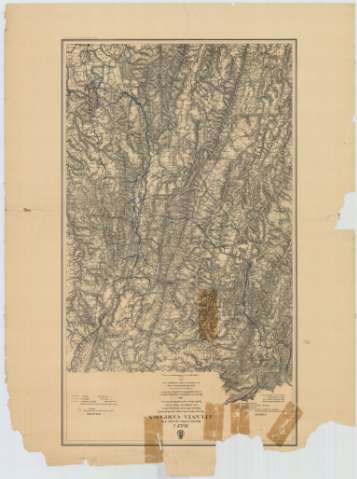
Map 1 illustrating the Military Operations of Atlanta...


 Maps, plans and nautical charts
Map 1 illustrating the Military Operations of Atlanta Campaign : This map embraces the region extending from the... (1875)
Maps, plans and nautical charts
Map 1 illustrating the Military Operations of Atlanta Campaign : This map embraces the region extending from the... (1875)
 Disponible Holdings
 Section: Maps, plans and nautical charts
Title: Map 1 illustrating the Military Operations of Atlanta Campaign : This map embraces the region extending from the Tennesse River to the Oostanaula River and exhibits the Works of the United States and Confederate Forces 1864 Maj. Genl. W. T. Sherman, commanding U.S. Forces Genl. J.E. Johnston, comanding Conf-Forces / Compiled by authority of the H. The Secretary of war in the Office of the Office of the Chief of Engineers, U.S.A., 1875
Material or type of resouce Area: [Ca. 1:86215], 3 statute miles [= 5,6 cm]
Publication: [Washington] : Office of the Chief of Engineers, 1875
Physical description: 1 mapa : col., montado sobre tela ; 88 x 51 cm
Content type: Imagen cartográfica
Media type: computadora
Carrier type: recurso en línea
Notes: Comprende la parte septentrional del estado norteamericano de Alabama y la noroccidental del de Georgia
Relieve representado por normales
Tabla de signos convencionales para señalar las operaciones efectuadas por los ejércitos federal y confederado en esta zona
Nota que señala todos aquellos trabajos tenidos en cuenta para la elaboración del presente mapa
Materia / lugar / evento: Operaciones bélicas
Mapas generales
1864
Georgia (Estados Unidos)
Estados Unidos
Other authors: Estados Unidos. Army. Office of the Chief of Engineers
UDC: 761-17
758-16
Type of publication:
Maps
Rights:
Préstamo:
Disponible
