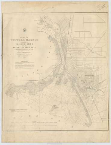
Chart of Buffalo Harbor and Head of Niagara River with...


 Maps, plans and nautical charts
Chart of Buffalo Harbor and Head of Niagara River with the Outlet of Lake Erie (1857)
Maps, plans and nautical charts
Chart of Buffalo Harbor and Head of Niagara River with the Outlet of Lake Erie (1857)
 Disponible Holdings
 Section: Maps, plans and nautical charts
Uniform title: BUFFALO (Estados Unidos) (Nueva York) (Puerto). Cartas náuticas. 1857. 1:30000 (1856)
Title: Chart of Buffalo Harbor and Head of Niagara River with the Outlet of Lake Erie / Compiled in the Bureau of Topl. Engrs. From the surveys of Capt. W.G. Williams, T.E. with recent corrections and additions by Capt. I.C. Woodruff, [sic] T.E. 1856 ; Engraved by W.H. Dougal
Material or type of resouce Area: Escala 1:30000
Publication: [Washington] : Bureau of Topl. Engrs., 1857
Physical description: 1 carta náutica ; 55 x 50 cm
Content type: Imagen cartográfica
Media type: computadora
Carrier type: recurso en línea
Series: (Survey of the Northern and North Western Lakes)
Notes: Escala también dada en forma gráfica de 2000 pies y 3 millas legales inglesas. Orientado al norte con flecha la que señala ademas la variación magnética observada
Relieve por normales
Indica sondas batimétricas y veriles, así como la dirección de las corrientes y las líneas de derrota a seguir para arribar al puerto
Clave hidrográfica para determinar la calidad del fondo
En nota se explican las diferentes derrotas a seguir para arribar al puerto
Materia / lugar / evento: Cartas náuticas
Batimetría
1856
1857
Other authors: Williams, W.G
Dougal, W. H
Woodroff, W.H
Estados Unidos. War Department. Engineer Bureau
UDC: 747-15
Type of publication:
Maps
Rights:
Préstamo:
Disponible
