L'Anse including Portage Entry and part of Keweenaw Bay...


 Maps, plans and nautical charts
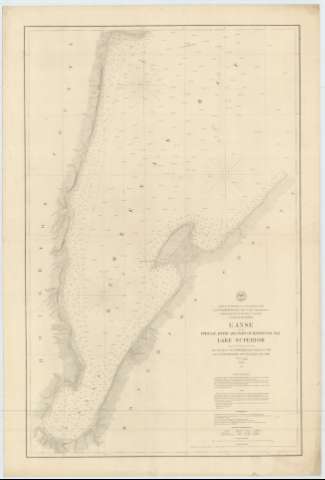
L'Anse including Portage Entry and part of Keweenaw Bay : Lake Superior (Published in 1866)
Maps, plans and nautical charts
L'Anse including Portage Entry and part of Keweenaw Bay : Lake Superior (Published in 1866)
 Disponible Holdings
 Section: Maps, plans and nautical charts
Title: L'Anse including Portage Entry and part of Keweenaw Bay : Lake Superior / Proyected from a Trigonometrical Survey under the orders of Col. J.D. Graham, Corps of Engineers in 1863 and of Col. W.F. Raynolds. A.D.C. Maj of Engrs. in 1864 & 1865
Material or type of resouce Area: Escala 1:30000 (O 88°29'40''--O 88°16'30''/N 46°59'00''--N 46°44'40'')
Publication: [Washington] : Under the Direction of the Burean of Engineers of the War Department, Published in 1866
Physical description: 1 carta náutica ; 88 x 56 cm
Content type: Imagen cartográfica
Media type: computadora
Carrier type: recurso en línea
Series: (urvey of the Northern and North Western Lakes)
Notes: Escala también dada en formas gráficas de 3000 yardas y 3 millas legales inglesas. Orientado con dos nudos de treinta y dos rumbos en uno de los cuales se señala además la variación magnética observada
Relieve por normales
Indica sondas batimétricas y veriles, así como las líneas de derrota a seguir para arribar a las bahías
Clave hidrográfica para determinar la calidad del fondo
En nota, se sañalan todos aquellos trabajos tenidos en cuenta para la elaboración del presente documento
En otra nota se indica la variación magnética de dos puntos del área representada, la fecha de la observación y quien la efectuó
Materia / lugar / evento: Cartas náuticas
Batimetría
Bahías
1866
Other authors: Graham, James Duncan
Raynolds, W. F
Estados Unidos. War Department. Engineer Bureau
UDC: 774-16
Type of publication:
Maps
Rights:
Préstamo:
Disponible
