Map of Franklin, TENN. : including field Works and...


 Maps, plans and nautical charts
Map of Franklin, TENN. : including field Works and positions of troops 4th. and 23rd. Corps, during the engagement... (189-?)
Maps, plans and nautical charts
Map of Franklin, TENN. : including field Works and positions of troops 4th. and 23rd. Corps, during the engagement... (189-?)
 Disponible Holdings
 Section: Maps, plans and nautical charts
Uniform title: FRANKLIN (Estados Unidos) (Tennessee). Operaciones bélicas. 189-. Escala indeterminada (1864)
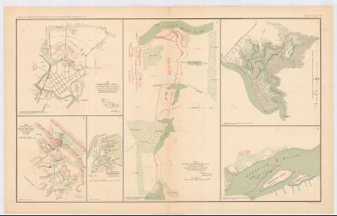
Title: Map of Franklin, TENN. : including field Works and positions of troops 4th. and 23rd. Corps, during the engagement of november 30th. 1864 / Maj. Gen. J.M. Schofield, Comdhg
Material or type of resouce Area: Escala indeterminada
Publication: Washington : Government Printing Office, [189-?] (N.Y. [Nueva York] : Julius Bien & co.)
Physical description: 1 mapa : col. ; 22x25 cm, en h. de 47x75 cm
Content type: Imagen cartográfica
Media type: computadora
Carrier type: recurso en línea
Notes: En : Atlas to accompany the Official Records of the Union and Confederate Armies 1861 - 1865. - Plate CXXXV - B, n 1
Relieve : líneas perpendiculares normales
Mapa que acompaña al informe del 'Capt. W.J. Twining'
Figura en margen inferior : Series 1. Vol XLV. Part 1
Representadas mediante diferentes colores las posiciones de los dos ejércitos
Figura rúbrica impresa
Orientado con flecha
En : Atlas to accompany the Official Records of the Union and Confederate Armies 1861 - 1865
Materia / lugar / evento: Guerra civil
Operaciones bélicas
Estrategia militar
Fortificaciones
Fortalezas militares
Líneas ferroviarias
Planos de población
1864
Estados Unidos
Other authors: Schofield, J.M Major General
UDC: 912:355.4]:[355.43+623.2+623.1+625.1](768 Franklin)'1864'
912:314(768 Franklin)(084.3)
768 Franklin
Type of publication:
Maps
Rights:
Préstamo:
Disponible
