Topographical map of California, Nevada, Oregon and part...


 Maps, plans and nautical charts
Topographical map of California, Nevada, Oregon and part of Idaho : 'Essayons' : prepared from fields surveis and... (189-?)
Maps, plans and nautical charts
Topographical map of California, Nevada, Oregon and part of Idaho : 'Essayons' : prepared from fields surveis and... (189-?)
 Disponible Holdings
 Section: Maps, plans and nautical charts
Uniform title: ESTADOS UNIDOS. O. Mapas topográficos. 189. 1:2011662 (1867)
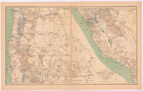
Title: Topographical map of California, Nevada, Oregon and part of Idaho : 'Essayons' : prepared from fields surveis and other reliable data / under the direction of But. Lt. Col. R.S. Willamson Corps of Engrs, U.S.A. ; drawn by W.B. Hyde, 1867
Material or type of resouce Area: Escala [ca. 1:2011662], 70 mile [= 5'6 cm]
Publication: Washington : Government Printing Office, [189-?] (N.Y. [Nueva York] : Julius Bien & co.)
Physical description: 1 mapa : col. ; 47 x 75 cm
Content type: Imagen cartográfica
Media type: computadora
Carrier type: recurso en línea
Notes: Relieve representado por normales
Coordenadas: (O125º-O114º/N46º30'-N32º). Meridiano de Washington
Mapa fraccionado en 3 secciones
En: Atlas to accompany the Official Records of the Union and Confederate Armies 1861-1865. P. CXXXIV, nº 1
Materia / lugar / evento: Guerra civil
Mapas topográficos
1867
California
Nevada
Oregón
Idaho
Estados Unidos
Other authors: Williamson, R. S
Hyde, W.B
UDC: (795)
Type of publication:
Maps
Rights:
Préstamo:
Disponible
