Map Prepared to exhibit the Campaigns in which the Army...


 Maps, plans and nautical charts
Map Prepared to exhibit the Campaigns in which the Army of the Cumberland took part during the war of the rebellion (189-?)
Maps, plans and nautical charts
Map Prepared to exhibit the Campaigns in which the Army of the Cumberland took part during the war of the rebellion (189-?)
 Disponible Holdings
 Section: Maps, plans and nautical charts
Uniform title: Estados Unidos. Geografía militar. 189. 1:1749272 (1861-1865)
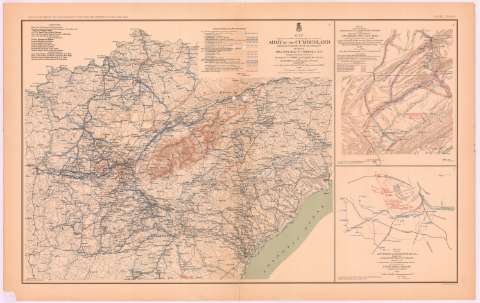
Title: Map Prepared to exhibit the Campaigns in which the Army of the Cumberland took part during the war of the rebellion / by order of Maj. Gen. Geo. H. Thomas, U.S.A. ; compiled under the direction of But. Maj. Gen. Z.B. Tower, Chief Engr. Milit. Div. of the tenn. ; by Ed. Ruger, Supt. Top'l Engr. Office at Nashville ; assistants Capt. A. Kilp and lieut R. Flach, 3rd U.S.C.A. (Heavy) and Asst. top. Engrs.
Material or type of resouce Area: Escala [ca. 1:1749272], 50 mile [= 4'6 cm]
Publication: Washington : Government Printing Office, [189-?] (N.Y. [Nueva York] : Julius Bien & co.)
Physical description: 1 mapa : col. ; 51x60 cm, en h. de 47x75 cm
Content type: Imagen cartográfica
Media type: computadora
Carrier type: recurso en línea
Notes: En : Atlas to accompany the Official Records of the Union and Confederate Armies 1861 - 1865. - Plate CXVIII, n 1
Relieve : lineas perpendiculares normales
Figura leyenda de autoridades
Leyenda de simbolos explicando posicion y movimiento de las tropas de cada General y de cada división
Figura en margen inferior : 'General map'
Representadas mediante distinto color las posiciones del ejercito federal y confederado
En : . Atlas to accompany the Official Records of the Union and Confederate Armies 1861 - 1865
Materia / lugar / evento: Guerra civil
Mapas militares
Itinerarios
Maniobras de campaña
S.XIX
Estados Unidos
Other authors: Tower, Z. B
Ruger, Edward
Kilp, A
Flach, R
UDC: 912:355.4]:[656.02+355.52](73-11)'1861/1865'
912:355(73-11)'1861/1865'
73-11
Type of publication:
Maps
Rights:
Préstamo:
Disponible
