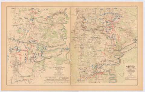
Battle - field of Winchester, VA. september 19, 1864 :...


 Maps, plans and nautical charts
Battle - field of Winchester, VA. september 19, 1864 : [map] (189-?)
Maps, plans and nautical charts
Battle - field of Winchester, VA. september 19, 1864 : [map] (189-?)
 Disponible Holdings
 Section: Maps, plans and nautical charts
Title: Battle - field of Winchester, VA. september 19, 1864 : [map] / prepared by But. Lt. Col. G.L. Gillespie, Major of Engineers, USA, from surveys under his directions, by order of Lt. Gen. P.H. Sheridan, and under the Authority of the Hon. Secretary of War, and of the Chief of Engineers, USA 1873 ; George B. Strauch, E. Siegesmund, assistants
Material or type of resouce Area: Escala [ca. 1:24016], 1 inchto 2200 feet
Publication: Washington : Government Printing Office, [189-?] (N.Y. [Nueva York] : Julius Bien & co.)
Physical description: 1 mapa : col. ; 42x34 cm, en h. de 47x75 cm
Content type: Imagen cartográfica
Media type: computadora
Carrier type: recurso en línea
Notes: En : Atlas to accompany the Official Records of the Union and Confederate Armies 1861-1865. - Plate XCIX, n 1
Relieve : curvas de niveles
Leyenda de signos utilizados
Figura en margen inferior : Series 1. Vol XLVIII
Representadas mediante distintos colores las posiciones de los dos ejércitos
Figura relación de las principales fuerzas de los dos ejércitos
En : Atlas to accompany the Official Records of the Union and Confederate Armies 1861-1865
Materia / lugar / evento: Guerra civil
Batallas
Estrategia militar
Baterías
Artillería de campaña
Arma de Caballería
Ejército de Tierra
Redes de transporte
Planos de población
1864
Estados Unidos
UDC: 912:355.4]:[355.422+355.43+357.1+623.413+355.351](755 Winchester)'1864'
912:314(755 Winchester)(084.3)
755 Winchester
Type of publication:
Maps
Rights:
Préstamo:
Disponible
