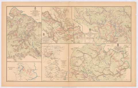
Map of the battle - field of the Wilderness, Va.


 Disponible Holdings
 Section: Maps, plans and nautical charts
Title: Map of the battle - field of the Wilderness, Va. / prepared by command of Brig. Gen. A.A. Humphreys, chief of Corps of Engineers U.S. Army, from surveys made under direction of BVT. Brig. Gen. N. Michler, Major of Engineers, 1867 ; surveyed and drawn by Maj. J.E. Weyss assisted by E. Theilkuhl... [et al.]
Material or type of resouce Area: Escala [ca. 1:50292], 1 mile [= 3'2 cm]
Publication: Washington : Government Printing Office, [189-?] (N.Y. [Nueva York] : Julius Bien & co.)
Physical description: 1 mapa : col. ; 31x20 cm, en h. de 47x75 cm
Content type: Imagen cartográfica
Media type: computadora
Carrier type: recurso en línea
Notes: En : Atlas to accompany the Official Records of the Union and Confederate Armies 1861-1865. - Plate XCVI, n 1
Relieve : líneas perpendiculares normales
Orientado con flecha
Figura en margen inferior : Series 1. Vol. XXXVI
Representadas mediante distintos colores las posiciones de ambos ejércitos
En : Atlas to accompany the Official Records of the Union and Confederate Armies 1861-1865
Materia / lugar / evento: Guerra de Secesión
Batalla de Wilderness
Estrategia militar
Redes de transporte
1861-1865
1864
Estados Unidos
Other authors: Humphreys, A. A (Andrew Atkinson), 1810-1883
Bien, Julius, 1826-1909
Michler, N
Weyss, J. E
Theilkuhl, F
Government Printing Office (Estados Unidos)
UDC: 912:355.4]:[355.422+355.43](755 Wilderness)'1867'
755 Wilderness
Type of publication:
 Maps
Maps
Rights:
Préstamo:
Disponible
