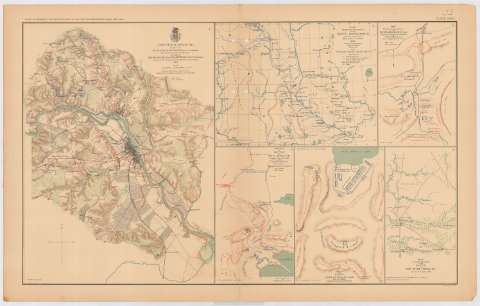
Fredericksburg : [map]


Section: Maps, plans and nautical charts
Uniform title: FREDERICKSBURG (Estados Unidos) (Virginia). Operaciones bélicas. 1892. 1:39252 (1867)
Title: Fredericksburg : [map] / prepared by But. Brig. Gen. N. Michler, Major of Engineers from Surveys under his direction by orden of Brig. Gen. & But. Maj. Gen. A.A. Humphreys, chief of Engineers and under the Authority of the Hon. Secretary of war 1867 ; Surveyed and drawn by Maj. J.E. Weyss assisted by F. Theilkul ... [et al. ]
Material or type of resouce Area: Escala [ca. 1:39252], 1 mile [= 4'1 cm]
Publication: Washington : Government Printing Office, [189-?] (N.Y. [Nueva York] : Julius Bien & co.)
Physical description: 1 mapa : col. ; 42x31 cm, en h. de 47x75 cm
Content type: Imagen cartográfica
Media type: computadora
Carrier type: recurso en línea
Notes: En : Atlas to accompany the Official Records of the Union and Confederate Armies 1861 - 1865. - Plate XXXIII, n 1
Relieve : líneas perpendiculares normales
Orientado con flecha
Figura en el margen inferior : 'Series 1. Vol. XXI'
Representada con distintos colores la disposición de ambos ejércitos
En : Atlas to accompany the Official Records of the Union and Confederate Armies 1861 - 1865
Materia / lugar / evento: Guerra civil
Operaciones bélicas
Estrategia militar
Planos de población
1867
Estados Unidos
Other authors: Michler, N
Bien, Julius, 1826-1909
Humphreys, A. A (Andrew Atkinson), 1810-1883
Weyss, J. E
Theilkuhl, F
UDC: 912:355.4]:[355.43](755 Fredericksburg)'1867'
912:314(755 Fredericksburg)(084.3)
755 Fredericksburg
Type of publication:
 Maps
Maps
Rights:
Préstamo:
 Disponible
