Reconnaisance of the Secession Works at Yorktown, VA, and...


 Maps, plans and nautical charts
Reconnaisance of the Secession Works at Yorktown, VA, and at Gloucestar, VA : May 4, 1862 (189-?)
Maps, plans and nautical charts
Reconnaisance of the Secession Works at Yorktown, VA, and at Gloucestar, VA : May 4, 1862 (189-?)
 Disponible Holdings
 Section: Maps, plans and nautical charts
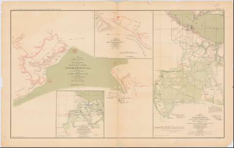
Title: Reconnaisance of the Secession Works at Yorktown, VA, and at Gloucestar, VA : May 4, 1862 / Made by Lievt. Abbot, top. Engrs., [and] Made by Lievt Comstock, Engrs., for Gen. J.G. Barnard Chief Engineer Army of Potomac
Material or type of resouce Area: Escala [ca. 1:6004], 1 inch = 500 feet
Publication: Washington : Government Printing Office, [189-?] (N.Y. [Nueva York] : Julius Bien & co.)
Physical description: 1 mapa : col. ; 52x56 cm, en h. de 47x75 cm
Content type: Imagen cartográfica
Media type: computadora
Carrier type: recurso en línea
Notes: En : Atlas to accompany the Official Records of the Union and Confederate Armies 1861 - 1865. - Plate XV, n 1
Relieve : lineas perpendiculares normales
Figura texto caligrafiado impreso
Orientado con flecha
Figura en margen inferior : Series 1. Vol. XI. Part. 1. Page 316
En : Atlas to accompany the Official Records of the Union and Confederate Armies 1861 - 1865
Materia / lugar / evento: Guerra civil
Fortificaciones
Estrategia militar
Artillería de campaña
1862
Yorktown
Gloucester (Estados Unidos)
Virginia
Estados Unidos
Other authors: Abbot, Henry L
Comstock, Cyrus Ballou
UDC: 912:355.4]:[623.4+355.43+623.413](755)'1862'
755
Type of publication:
Maps
Rights:
Préstamo:
Disponible
