Map showing the system of rebel fortifications on the...


 Maps, plans and nautical charts
Map showing the system of rebel fortifications on the Mississippi river at island n 10 and New Madrid : also the... (189-?)
Maps, plans and nautical charts
Map showing the system of rebel fortifications on the Mississippi river at island n 10 and New Madrid : also the... (189-?)
 Disponible Holdings
 Section: Maps, plans and nautical charts
Uniform title: Estados Unidos. E. Fortificaciones. 1890 (1861-1865). 1:170687
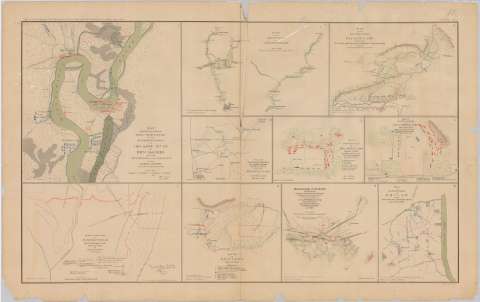
Title: Map showing the system of rebel fortifications on the Mississippi river at island n 10 and New Madrid : also the operations of the U.S. forces under General John Pope against these positions
Material or type of resouce Area: Escala [ca} 1:170687], 7 miles [= 6'6 cm]
Publication: Washington : Government Printing Office, [189-?] (N.Y. [Nueva York] : Julius Bien & co.)
Physical description: 1 mapa : col. ; 26x26 cm, en h. de 47x75 cm
Content type: Imagen cartográfica
Media type: computadora
Carrier type: recurso en línea
Notes: En : Atlas to accompany the Official Records of the Union and Confederate Armies 1861 - 1865. - Plate X, n 1
Figura en el margen inferior : 'Series 1. vol. 8 Page 85
Representadas con distintos colores las fuerzas de los dos ejércitos
En : Atlas to accompany the Official Records of the Union and Confederate Armies 1861 - 1865
Materia / lugar / evento: Guerra civil
Fortificaciones
Baterías
Operaciones navales
1890
Tennessee
Missouri
Estados Unidos
UDC: 912:355.4]:[623.2+623.1+355.46](73)'1861/1865'
73
Type of publication:
Maps
Rights:
Préstamo:
Disponible
