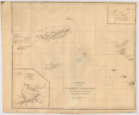
Chart of the Virgin Islands from the Spanish survey with...


 Maps, plans and nautical charts
Chart of the Virgin Islands from the Spanish survey with two additional harbours (February 19th. 1808)
Maps, plans and nautical charts
Chart of the Virgin Islands from the Spanish survey with two additional harbours (February 19th. 1808)
 Disponible Holdings
 Section: Maps, plans and nautical charts
Uniform title: VIRGENES (Islas). Cartas náuticas. 1:422476 (1808)
Title: Chart of the Virgin Islands from the Spanish survey with two additional harbours / E. Jones sculpt
Material or type of resouce Area: Escala [ca. 1:422476] (O 65°40'00''--O 62°51'30''/N 19°05'00''--N 16°50'00'')
Publication: London : published by A. Arrowsmith, 10 Soho square, February 19th. 1808
Physical description: 1 carta náutica : Papel agarbanzado con marca de aguas:"J. Whatman / 18-1" [1801 o 1861] ; 65 x 79 cm
Content type: Imagen cartográfica
Media type: computadora
Carrier type: recurso en línea
Notes: Escala hallada a partir de 1° de latitud [= 26'3 cm]. Orientado con nudo de rumbos
Relieve por normales
Indica sondas batimétricas, veriles y fondeaderos
Inserta: "The Western part of Normans Island one of the Virgin Isles". Escala [ca. 1:15433] ; [Northern Sound of Virgin Gorda]. Escala [ca. 1:64374], halladas ambas escalas por comparación con otros documentos de características similares
Sello del depósito general topográfico de ingenieros
Materia / lugar / evento: Cartas náuticas
Batimetría
Islas
Estrechos
1808
Norman (Isla)
Virgen Gorda (Isla)
Other authors: Arrowsmith, Aaron, 1750-1823
Jones, Edward, fl. 1807
UDC: 729.72
Type of publication:
Maps
Rights:
Préstamo:
Disponible
