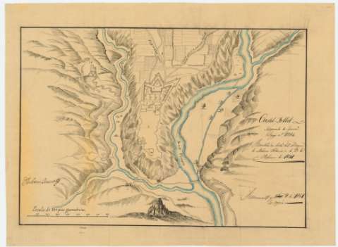
Castel-Follit


Section: Maps, plans and nautical charts
Title: Castel-Follit / [Jose Aparici]
Material or type of resouce Area: Escala [ca. 1:1.766]. 800 pies geométricos [= 12,5 cm]
Publication: 1851 nov. 8
Physical description: 1 plano : ms., col. ; 31 x 45 cm en h. de 38 x 52 cm
Content type: Imagen cartográfica
Media type: computadora
Carrier type: recurso en línea
Notes: Presenta el plano y alrededores
Rubricado por Ambrosio Borsano
Manuscrito fechado en Simancas
A plumilla en tinta negra y coloreado a la acuarela en azul
Es copia del original de 1691
Relieve representado por normales
Clave numérica para las partes, sin aparecer la relación
Indica tierras de cultivo
"Negociado de Guerra. Legajo nº 2884"
"Remitido en Carta del Duque de Medina Sidonia de 3 de Febrero de 1691"
Procede de la "Colección Aparici"
Materia / lugar / evento: Planos de población
Tierras de cultivo
Caminos
1691
Castellfullit de la Roca
Gerona (Provincia)
Cataluña
España
Other authors: Aparici y García, José, 1791-1857
UDC: 460.233Castellfullit de la Roca
Type of publication:
 Maps
Maps
Rights:
Préstamo:
 Disponible
