Wrangel - Land und Ubersicht der Entdeckungsgeschichte im...


 Maps, plans and nautical charts
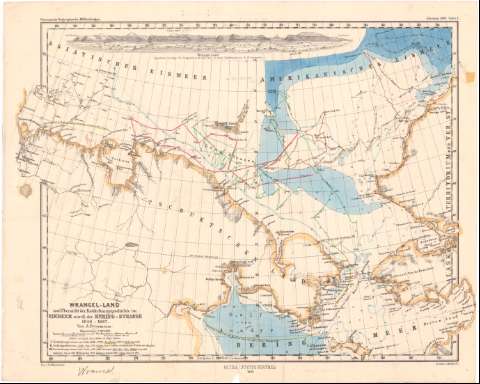
Wrangel - Land und Ubersicht der Entdeckungsgeschichte im Eismeer nordl der Bering - Strasse 1648-1867 (1869)
Maps, plans and nautical charts
Wrangel - Land und Ubersicht der Entdeckungsgeschichte im Eismeer nordl der Bering - Strasse 1648-1867 (1869)
 Disponible Holdings
 Section: Maps, plans and nautical charts
Title: Wrangel - Land und Ubersicht der Entdeckungsgeschichte im Eismeer nordl der Bering - Strasse 1648-1867 / Van A. Pettermann ; Gez. V. Fr. Hanemann ; druck V.C. Hellfarth
Material or type of resouce Area: Escala 1:5000000 ; [proyec. cónica] (E160°-E156°/N73°-N68°)
Publication: Gotha : Justus Perthes, 1869
Physical description: 1 mapa : col. ; 27,7x34,7 cm
Content type: Imagen cartográfica
Media type: computadora
Carrier type: recurso en línea
Notes: Pertenece al 'Petermann's Geographische Mittheilungen. - Tafel 2'
Presenta además una vista
Escalas gráficas de 15 millas alemanas [= 3 cm] y 60 millas náuticas [= 2,2 cm]. Red geográfica de 1° en 1°
Relieve representado por normales
Relación de las principales rutas expedicionarias indicadas por clave numérica y cromática
Procede de la 'Colección Coello'
Materia / lugar / evento: Expediciones geográficas
1869
Mar de Bering
Other authors: Petermann, Augustus Herman
Hanemann, Fritz, 1847-1877
Hellfarth, C
Perthes, Justus, 1749-1816
UDC: 912:910.4(26 Chukchi)'1869'
(265.25 Bering)
Type of publication:
Maps
Rights:
Préstamo:
Disponible
