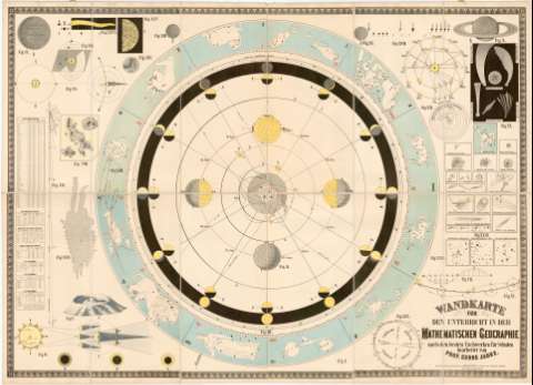
Wandkarte fur den unterricht in der Mathematischen...


 Maps, plans and nautical charts
Wandkarte fur den unterricht in der Mathematischen Geographie... (187- ?)
Maps, plans and nautical charts
Wandkarte fur den unterricht in der Mathematischen Geographie... (187- ?)
 Disponible Holdings
 Section: Maps, plans and nautical charts
Uniform title: UNIVERSO. Mapas celestes (187-). Escala indeterminada
Title: Wandkarte fur den unterricht in der Mathematischen Geographie... / Bearbeitet von Prof. Georg Jausz
Material or type of resouce Area: Escala indeterminada
Publication: In Olmutz : Verlag v. Eduard Holzel, [187- ?]
Physical description: 1 carta celeste ; 1 hemisferio, 140x78 cm pleg. en 70x13 cm
Content type: Imagen cartográfica
Media type: computadora
Carrier type: recurso en línea
Notes: Presenta además 23 figuras de datos cosmográficos
Representa las constelaciones por sus signos primitivos
Entelado en 12 cuarterones
Materia / lugar / evento: Mapas celestes
S.XIX
Other authors: Wetzel, E
Jauz, Georg
Holzel, Eduard
UDC: 912:[523/524]:524.8'1870/1879'
Type of publication:
Maps
Rights:
Préstamo:
Disponible
