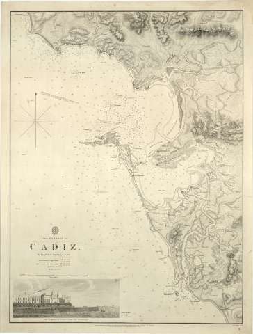
The Harbour of Cadiz


Section: Maps, plans and nautical charts
Uniform title: CÁDIZ (Golfo). Cartas náuticas. 1837. 1:58.000
Title: The Harbour of Cadiz / By Captr. W.H. Smyth, R.N.F.R.S. ; J. & C. Walker Sculpt
Material or type of resouce Area: Escala [ca. 1:58000], 3 Nautie Miles [= 9,6 cm]
Publication: London : Published according to Act of Parliament, at the Hydrographical Office of the Admiralty : Sold by R.B. Bate Acent the Sale of the Admiralty Charts 21 Poultry, augst. 16th 1837
Physical description: 1 carta naútica : montada sobre tela ; 58,8 x 44,1 cm en h. de 62,6 x 48,1 cm
Notes: Comprende la bahía y el golfo de Cádiz
Coordenadas del faro de San Sebastián y del observatorio de San Fernando referidas al meridiano de Greenwich. Orientada con lis y rosa de los vientos en gráfico de declinación magnética
Relieve representado por normales
Indica veriles, bajos y sondas batimétricas
Sello del "Hidrographical Office, Price 2s."
En el ángulo inferior derecho: "86"
Inserta: The alameda of Cadiz from the Anchorage
Materia / lugar / evento: Cartas náuticas
Puertos
Observatorios astronómicos
Golfos
Bahías
Faros
1837
Cádiz (Golfo)
Cádiz (España, Bahía)
Cádiz (Provincia)
Andalucía
Other authors: Smyth, W. H (William Henry), 1788-1865
Bate, R. B
Gran Bretaña. Hydrographic Department
J. & C. Walker
UDC: (60.355 Cádiz)
Type of publication:
 Maps
Maps
Rights:
Préstamo:
 Disponible
