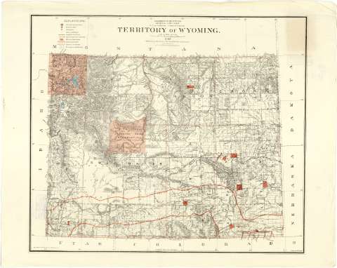
Territory of Wyoming


Section: Maps, plans and nautical charts
Uniform title: WYOMING (Estados Unidos). Mapas generales. 1:950400 (1883)
Title: Territory of Wyoming / Department of the Interior, General Land Office, N.C.Mc. Farland, Commisioner; Compiled from the official Records of the Genral Land Office and other sources under supervisión of G.P. Strum, principal dranghtsman G.L.O.; Drawn by M. Hendges.
Material or type of resouce Area: Escala [1:950400 ; proy. cónica equidistante] (O 111°--O 104°/N 45°--N 41°)
Publication: N.Y.[i.e. New York] : Photo lith & by Julius Bien & Co., 139 Duane St., 1883
Physical description: 1 mapa : col. ; 62 x 72 cm
Content type: Imagen cartográfica
Media type: computadora
Carrier type: recurso en línea
Notes: Escala nominal de 15 millas por pulgada y gráfica de 50 millas estatutarias [=8'4 cm]. Coordenadas también referidas al meridiano de Washington (O 34°--O 27°). Red geográfica de 1° en 1°
Orográfia por normales
Sobre el mapa aparece trazada una retícula, marcadas con números arábigos tanto las abcisas como las ordenadas, que parece ser un sistema de localización de aquellos municipios sobre los que se han realizado mediciones catastrales
Destaca los territorios que constituyen reservas indias, especificándose la fecha y referencia legal de los tratados por los cuales fueron establecidas.
Tabla de los signos empleados para indicar; la situación de las llamadas "Surveyor General's Office" y "U.S. Land Office" capitales de condado, límites entre éstos últimos, reservas militares líneas ferroviarias y aquellosmunicipios cuya demarcación no ha sido establecida
Impresa en rojo y azul
Materia / lugar / evento: Divisiones administrativas
Mapas generales
Municipios
Campamentos militares
Poblaciones indígenas
1883
Other authors: McFarland, N. C
Dalrymple, Alexander
Bien, Julius, 1826-1909
Strum, G.P
Hendges, M
Estados Unidos. Department of the Interior. General Land Office
UDC: 912:355.71:397(787-28)"1883"
787
Type of publication:
 Maps
Maps
Rights:
Préstamo:
 Disponible
