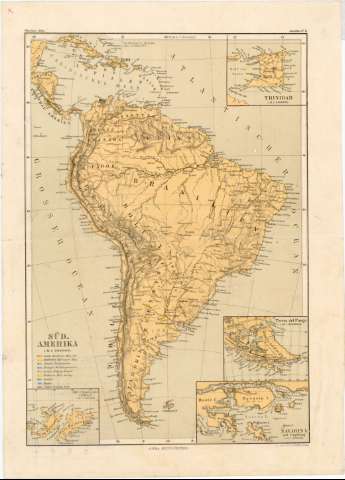
Süd-Amerika


Section: Maps, plans and nautical charts
Uniform title: AMERICA DEL SUR. Mapas generales. 1:30000000 (18)
Title: Süd-Amerika / Justus Perthes ; Lith. Anst. von C. Hellfarth in Gotha
Material or type of resouce Area: 1:30000000 (O 90°-O 30°/N 25°-S 59°)
Publication: Gotha : Justus Perthes, [1877-1882?]
Physical description: 1 mapa : col. ; 32 x 22 cm
Content type: Imagen cartográfica
Media type: computadora
Carrier type: recurso en línea
Notes: Figura la represenación de la orografía e hidrografía y la localización de las tribus indias, con una clave de los colores empleados para señalar las misiones pertenecientes a diversas confesiones
Fecha de publicación tomada del catálogo del SGE: "Indice de mapas y planos históricos de América". 1974
Proyec. Guillermo Postel Meridiana. Red geográfica de 10 en 10
Relieve representado por normales
Inserta: "Trinidad". Escala 1:30000000 ; "Die Falkland Insel". Escala 1:5000000 ; "Tierra del Fuego" . Escala 10000000 ; "Navarin I. und Umgebung". Escala 2250000
Hoja suelta, que pertenece a "Missions Atlas Amérika", n. 11
Materia / lugar / evento: Mapas generales
Misiones
Poblaciones indígenas
S.XIX
América del Sur
Other authors: Hellfarth, C
Perthes, Justus, 1749-1816
UDC: 912:266]:397(8)"1877/1882"
8
Type of publication:
 Maps
Maps
Rights:
Préstamo:
 Disponible
