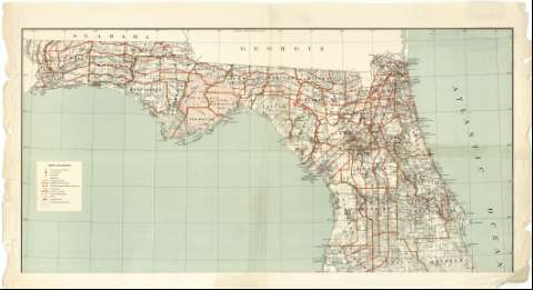
State of Florida


Section: Maps, plans and nautical charts
Uniform title: FLORIDA (Estados Unidos). Mapas generales. 1:760320 (1883)
Title: State of Florida / Department of the Interior, General Land Office, N.C.Mc. Farland Commissioner ; compiled from the official Records of the General Land Office and other sources under the supervision of G.P. Strum, Principal Draughtsman G.L.O.
Material or type of resouce Area: Escala [1:760320 ; proy. cónica equidistante] (O 87°39'--O 79°45'/N 31°07'--N 24°20')
Publication: N.Y. [i.e. New York] : Photo Lith & print by Julius Bien & Co. 139 Duane St..., 1883
Physical description: 1 mapa en 2 hoja : col. ; 100 x 100 cm, hoja de 69 x 106 cm o menor
Content type: Imagen cartográfica
Media type: computadora
Carrier type: recurso en línea
Notes: Escala nominal de 12 millas por pulgada y gráfica de 50 millas [= 10'7 cm]. Coordenadas también referidas al meridiano de Washington (O 10°25'--O 3°00'). Red geográfica de 30' en 30'
Sobre el mapa aparece trazada una retícula, marcada con números arábigos tanto las abcisas como las ordenadas, que parece ser un sistema de localización de aquellos municipios sobre los que se han realizado mediciones catastrales
Tabla de los signos convencionales empleados para indicar: la situación de los llamados "Surveyor General's Office" y "U.S. Land Office", núcleos de población, destacándose las capitales de condados, límites entre éstos últimos, reservas militares, concesiones de tierras, líneas ferroviarias, etc
Impreso en rojo, verde y siena
Materia / lugar / evento: Divisiones administrativas
Mapas generales
Municipios
Parcelación
Campamentos militares
1883
Other authors: McFarland, N. C
Strum, G.P
Estados Unidos. Department of the Interior
Estados Unidos. General Land Office
Julius Bien & Co
UDC: 912:323.22.155.64:355.71(759-28)"1883"
759
Type of publication:
 Maps
Maps
Rights:
Préstamo:
 Disponible
