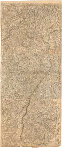
Seat of War on the Rhine being a New Map of the Course of...


 Maps, plans and nautical charts
Seat of War on the Rhine being a New Map of the Course of that River from Basil to Bonn with the Adjacent Countries (175- ?)
Maps, plans and nautical charts
Seat of War on the Rhine being a New Map of the Course of that River from Basil to Bonn with the Adjacent Countries (175- ?)
 Disponible Holdings
 Section: Maps, plans and nautical charts
Uniform title: RHIN (Alemania) (Río). Cuencas fluviales (175). 1:220000
Title: Seat of War on the Rhine being a New Map of the Course of that River from Basil to Bonn with the Adjacent Countries / By Monsr. W. del L'Isle Geogr.
Material or type of resouce Area: Escala [ca. 1:220000], 15 English Miles [= 11 cm]
Publication: [London ? : Printed for Robt. Wilkinson, [175- ?]
Physical description: 1 mapa : col. ; 139,4x59 cm pleg. en 71x59 cm
Content type: Imagen cartográfica
Media type: computadora
Carrier type: recurso en línea
Notes: Coordenadas referidas al meridiano de Londres (E6°42'-E8°53'/N50°36'-N47°25')
Relieve representado por normales
Indica núcleos de población mediante edificios de perfil y masas forestales
Materia / lugar / evento: Cuencas hidrográficas
Siglo XVIII
Other authors: Wilkinson, Robert, fl. 1785-1825
UDC: 912:551.482(282.2 Rhin)(430)
282.2 Rhin)(430
Type of publication:
Maps
Rights:
Préstamo:
Disponible
