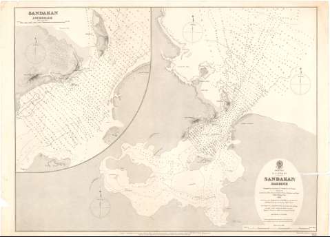
Sandakan Harbour


Section: Maps, plans and nautical charts
Uniform title: SANDAKAN (Malasia). Cartas náuticas. 1883. 1:86600 (1881-1883)
Title: Sandakan Harbour / Surveyed by Lientenant & Commander R.F. Hoskyn assisted by Lientenants Pirie... [et. al] ; Engraved by Davies & Company
Material or type of resouce Area: Escala 1:86600
Publication: London : Published at the Admiralty..., 23d. Jany. 1883 (Sold by J.D. Potter Agent for the sale of the Admiralty Charts 31 & 11 King St. Tower Hill)
Physical description: 1 Carta náutica ; 49x68,7 cm
Content type: Imagen cartográfica
Media type: computadora
Carrier type: recurso en línea
Notes: Coordenadas de la ciudad de Flagstaff (E118°7'12''/N5°50'22''). Orientado con estrella y media lis en gráfico de declinación magnética
Relieve representado por normales
Indica veriles, bajos y sondas batimétricas en brazas. Clave hidrográfica para determinar la calidad del fondo
Nota relativa a las alturas, variación magnética
Inserta : Sandakan Auchorage. - Escala 1:40000 [= 4,7 cm]
Procede de la 'Colección Coello'
Materia / lugar / evento: Cartas náuticas
Costas
Topónimos antiguos
1883
Sandakan (Puerto)
Other authors: Hoskyn, R.F
Pirie
Potter, J.D
Davies & Company
Gran Bretaña. Hydrographic Department
UDC: 912:[551.46:551.468](91 Sandakan)'1881/1883'
91 Sandakan
Type of publication:
 Maps
Maps
Rights:
Préstamo:
 Disponible
