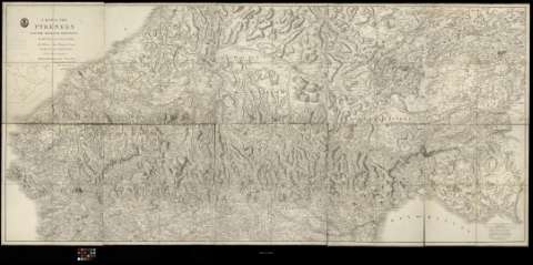
A Map of the Pyrenees and the adiacent provinces


 Maps, plans and nautical charts
A Map of the Pyrenees and the adiacent provinces (5th. January 1809)
Maps, plans and nautical charts
A Map of the Pyrenees and the adiacent provinces (5th. January 1809)
 Disponible Holdings
 Section: Maps, plans and nautical charts
Uniform title: PIRINEOS (Cordillera). Mapas generales. 1:220.000 (1809)
Title: A Map of the Pyrenees and the adiacent provinces / by Roussel and Blottiere ; with Additions from Tofirio and Lopez... ; by his royal Nighnes's... A. Arrowsmith...
Material or type of resouce Area: Escala [ca. 1:220.000]. 5 lienes [= 13,2 cm]
Publication: London : by A. Arrowsmith 10 Soho Square, 5th. January 1809
Physical description: 1 mapa en 10 h. : montado sobre tela ; 101 x 214 cm en h. de 50,5 x 42,8 cm o menos
Content type: Imagen cartográfica
Media type: computadora
Carrier type: recurso en línea
Notes: Escalas gráficas de '15 Geographical miles' [= 13 cm] y '15 english statute miles' [= 11,6 cm]. Orientado con lis
Relieve representado por sombreado
Nota sobre los mapas que han servido de base para la formación de éste
Dedicatoria: To his Royal Highness The Prince of Wales
FRN
Materia / lugar / evento: Mapas generales
Montañas
Fronteras
Guerras de independencia
1809
Francia
España
España - Historia - 1808-1814 (Guerra de la Independencia)
Other authors: Roussel , Ingeniero militar, 1733
La Blottière, Françoise de, 1673-1739
Tofiño de San Miguel, Vicente, 1732-1795
López, Tomás, 1730-1802
Arrowsmith, Aaron, 1750-1823
UDC: 912:[551.43:341.222](234 Pirineos)'1809'
234 Pirineos
Type of publication:
Maps
Rights:
Préstamo:
Disponible
