Przewalsk's Reisen von Peking nach Tibet & C. 1870-1873...


 Maps, plans and nautical charts
Przewalsk's Reisen von Peking nach Tibet & C. 1870-1873 Nebst Ubersicht der neveren Reisen in der Mongolei (1876)
Maps, plans and nautical charts
Przewalsk's Reisen von Peking nach Tibet & C. 1870-1873 Nebst Ubersicht der neveren Reisen in der Mongolei (1876)
 Disponible Holdings
 Section: Maps, plans and nautical charts
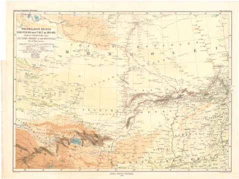
Uniform title: Mongolia. Expediciones geográficas. 1876. 1:4500000 (1870-1873)
Title: Przewalsk's Reisen von Peking nach Tibet & C. 1870-1873 Nebst Ubersicht der neveren Reisen in der Mongolei / von A. Petermann ; autogr. von B. Domann ; druck von C. Hellfarth in Gotha
Material or type of resouce Area: Escala 1:4500000 ; [proyec. cónica] (E93°00'-E116°20'/N47°50'-N34°00')
Publication: Gotha : Justus Perthes, 1876
Physical description: 1 mapa : col. ; 36x49 cm en h. de 40x52,5 cm
Content type: Imagen cartográfica
Media type: computadora
Carrier type: recurso en línea
Notes: Escalas gráficas de 20 millas alemanas [= 3,3 cm] y 150 'Russische Werst' [= 3,5 cm], Red geográfica de 2° en 2°
Relieve representado por sombreado, tintas hipsométricas y puntos acotados
Tabla de signos convencionales para indicar núcleos de población de distinta categoria, ruinas, fuentes, itinerarios, de las expediciones etc.
Procede de la 'Colección Coello'
UDC: 912:910.4(517)'1870/1873'
(510-16)
Type of publication:
Maps
Rights:
Préstamo:
Disponible
