Politisch-militarische Karte von Sud Afrika : zur...


 Maps, plans and nautical charts
Politisch-militarische Karte von Sud Afrika : zur Veranschaulichung der Kampfe zwischen Buren und Englandern bis... (1899)
Maps, plans and nautical charts
Politisch-militarische Karte von Sud Afrika : zur Veranschaulichung der Kampfe zwischen Buren und Englandern bis... (1899)
 Disponible Holdings
 Section: Maps, plans and nautical charts
Uniform title: AFRICA. Mapas generales. 1:4000000 (1899)
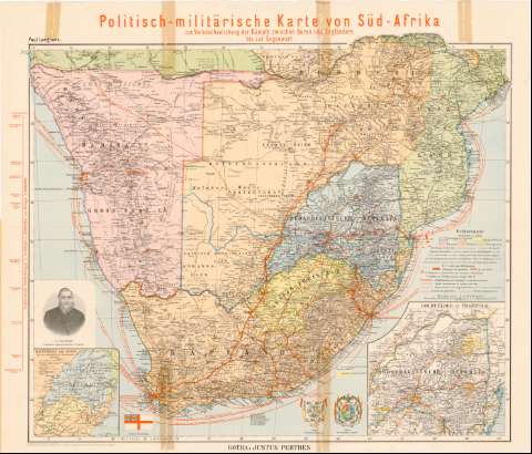
Title: Politisch-militarische Karte von Sud Afrika : zur Veranschaulichung der Kampfe zwischen Buren und Englandern bis zur Gegenwart / Paul Langhans ; Aus : Habenicht...
Material or type of resouce Area: 1:4000000 (E 11°00'-E 40°20'/S 16°00'-S 35°40')
Publication: Gotha : Justus Perthes, 1899
Physical description: 1 mapa : col. ; 64 x 75 cm
Content type: Imagen cartográfica
Media type: computadora
Carrier type: recurso en línea
Notes: Proyec. ortográfica meridiana o sinusoidal
Red geográfica de 2° en 2°
Relieve representado por sombreado
Relación de los principales estados coloniales indicados por clave cromática
Tabla de signos convencionales para indicar fortificaciones, compañías, líneas ferroviarias, telégrafos, líneas marítimas, etc.
Representación de S.J. Paul Kruger, Presidente de la República Sudafricana, dos escudos y una bandera
Inserta: Hauptteks der Buren die zur Grundung ihrer Freistaaten fuhrten. Escala 1:8000000
En: Deutscher Kolonial-Atlas
Sello del Depósito de la Guerra
Other authors: Langhans, Paul
Habenicht, Hermann
Perthes, Justus, 1749-1816
UDC: 912(6-13)'1899'
6-13
Type of publication:
Maps
Rights:
Préstamo:
Disponible
