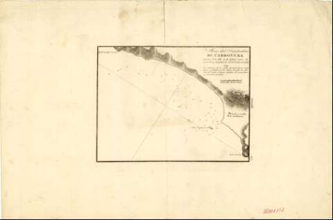
Plano del Fondeadero de Carbonera


Section: Maps, plans and nautical charts
Title: Plano del Fondeadero de Carbonera / [Dirección Hidrográfica]
Material or type of resouce Area: Escala [ca. 1:29.000]
Publication: [Cádiz] : [Dirección Hidrográfica], [1813]
Physical description: 1 carta náutica ; 18 x 24 cm
Content type: Imagen cartográfica
Media type: computadora
Carrier type: recurso en línea
Notes: Mención de responsabilidad y pie de imprenta tomados de la portada del atlas
Escala gráfica de 1/2 milla marítima [= 3,2 cm]. Coordenadas del castillo referidas al meridiano de Cádiz (E 4°23'30"/N 36°57'30")
Orientado con flecha en nudo de cuatro rumbos
Relieve representado por normales
Indica sondas batimétricas y fondeaderos
Clave hidrográfica para determinar la calidad del fondo
Señala la situación del pueblo y castillo de Carboneras
En el margen derecho: "Granada"
Esta carta náutica se publicó también en el "Portulano de la Península de España : Quaderno 3, Costas de Granada y Sevilla"
Materia / lugar / evento: Cartas náuticas
Fondeaderos
1813
Carboneras
Almería (Provincia)
Andalucía
España
Other authors: España. Dirección de Hidrografía
UDC: (460.358 Carboneras)
Type of publication:
 Maps
Maps
Rights:
Préstamo:
 Disponible
