Specialkart over Den Norske Kyst fra Jaederens Rev til...


 Maps, plans and nautical charts
Specialkart over Den Norske Kyst fra Jaederens Rev til Tanangerhaug (1862)
Maps, plans and nautical charts
Specialkart over Den Norske Kyst fra Jaederens Rev til Tanangerhaug (1862)
 Disponible Holdings
 Section: Maps, plans and nautical charts
Uniform title: ROGALAND (Noruega) (Condado). Cartas nauticas. 1:50000 (1862)
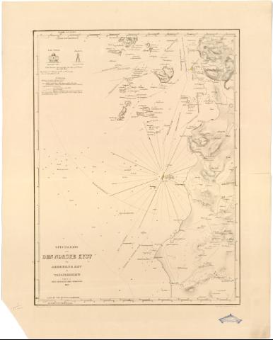
Title: Specialkart over Den Norske Kyst fra Jaederens Rev til Tanangerhaug / Uggivet af Den Geografiske Opmaaling ; Tegnet af T. Bang ; Lith. i Carl Schwensens
Material or type of resouce Area: Escala [ca. 1:50000]
Publication: [Christiania (Oslo) : Den Geografiske Opmaaling], 1862
Physical description: 1 carta nautica : col. ; 53,3x40 cm en h. de 66x52 cm
Notes: Presenta además dos alzados
Escala hallada a partir de un minuto de latitud [= 3,5 cm]. Coordenadas referidas al meridiano de Oslo (O5#25'-O5#06'/N58#57'-N58#43') y referidas al meridiano de Hierro. Recuadro geográfico de 1' en 1'. Orientado con flecha en nudo de rumbos. Figura angulo de declinación magnética
Relieve representado por normales y curvas de configuración
Indica veriles, bajos, fondeaderos y sondas batimétricas. Clave hidrográfica para determinar la calidad del fondo
Señala faros con el fanal iluminado en amarillo y rojo
Procede de la 'Colección Rico y Sinobas'
Materia / lugar / evento: Cartas náuticas
1862
Other authors: Bang T
Schwensen, Carl
Noruega. Geografiske opmaaling
UDC: 912:551.42(481-328 Rogaland)'1862'
481-328 Rogaland
Type of publication:
Maps
Rights:
Préstamo:
Disponible
