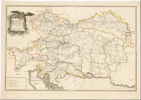
Postkarte Saemtlicher K : K : teutsch und hunganscher...


 Maps, plans and nautical charts
Postkarte Saemtlicher K : K : teutsch und hunganscher Erblaender (1788)
Maps, plans and nautical charts
Postkarte Saemtlicher K : K : teutsch und hunganscher Erblaender (1788)
 Disponible Holdings
 Section: Maps, plans and nautical charts
Uniform title: Europa. Central. Mapas generales. 1:1870000 (1788)
Title: Postkarte Saemtlicher K : K : teutsch und hunganscher Erblaender / Gzeichnet vom F.L.K.K.H.P.B.R.O. ; In Commission bey Sebastian Hartl Buchhandler in der Saigerstrasse
Material or type of resouce Area: Escala [ca. 1:1870000]
Publication: [Alemania ? : s.n.], 1788
Physical description: 1 mapa : col. ; 44x18 cm en h. de 50x71 cm
Notes: Tabla de signos convencionales para indicar oficinas de correos y limites administrativos
Título enmarcado en cartela barroca decorado con aguila imperial
Materia / lugar / evento: Mapas generales
Correos
1788
Italia
Yugoslavia
Hungría
República Checa
Other authors: Hartl, Sebastian
UDC: 912:383(4-191.2)'1788'
(45)
(497.1)
(439)
Type of publication:
Maps
Rights:
Préstamo:
Disponible
