Original karte zur Ubersicht des Standpunktes neuester...


 Maps, plans and nautical charts
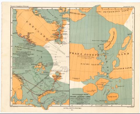
Original karte zur Ubersicht des Standpunktes neuester Polarforschungen bis Ende September 1874 (1874)
Maps, plans and nautical charts
Original karte zur Ubersicht des Standpunktes neuester Polarforschungen bis Ende September 1874 (1874)
 Disponible Holdings
 Section: Maps, plans and nautical charts
Title: Original karte zur Ubersicht des Standpunktes neuester Polarforschungen bis Ende September 1874 / Von A. Petermann ; Autogr. v. Peip. & B. Domann
Material or type of resouce Area: Escala 16000000 (O 85°-E 85°/N 90°-N 55°)
Publication: Gotha : Justus Perthes, 1874 (Gotha : Druck v. C. Hellfarth)
Physical description: 1 mapa : col. ; 25,8 x 14,8 cm en h. de 27,7 x 34,6 cm
Notes: En: 'Petermann's Geographische Mittheilungen. Jahrgang 1874. Tafel 20'
Escala gráfica de 100 millas náuticas [= 1,2 cm]. Red geográfica de 10° en 10°
Tabla de signos convencionales para indicar las diferentes expediciones en la zona polar
En: 'Petermann's Geographische Mittheilungen. Jahrgang 1874. Tafel 20'
Provisorische Skizze von Franz Joseph Land entdeckt von der 2 Osterr-ungar Nordpolar-Expedition 1873 & 1874
Other authors: Petermann, Augustus Herman
Domann, B
Peip, C
Perthes, Justus, 1749-1816
Hellfarth, C
UDC: 912:656.02(98)'1616/1874'
(988)
Type of publication:
Maps
Rights:
Préstamo:
Disponible
