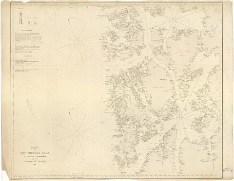
Kart over Den Norske Kyst fra Espevaer til Korsfjord


 Disponible Holdings
 Section: Maps, plans and nautical charts
Uniform title: HORDALAND (Noruega). Cartas náuticas. 1:100000 (1865)
Title: Kart over Den Norske Kyst fra Espevaer til Korsfjord / udgivet af Den geografiske Opmaaling ; Hydrograferet og tegnet af C.F. Wille ; Graveret af Aheimburger
Material or type of resouce Area: Escala [ca. 1:100000 ; proyec. Mercator] (E4#22'-E5#51'/N60#10'-N59#33')
Publication: [Christiania (Oslo)] : Den geografiske Opmaaling], 1865
Physical description: 1 carta nautica : col., montada sobre tela ; 73,8x94 cm
Notes: Presenta además tres alzados
Escala hallada a partir de cinco minutos de latitud [= 9,9 cm]. Escala gráfica de 60 Alen [= 7,3 cm]. Coordenadas referidas al meridiano de Oslo (O6#22'-O4#52'/N60#10'-N59#33') y referidas al meridiano de París. Red geográfica de 20' en 20'. Orientado con flecha en nudo de rumbos prolongados. Figura ángulo de declinación magnética
Relieve representado por normales
Indica veriles, bajos, fondeaderos y sondas batimétricas. Clave hidrográfica para determinar la calidad del fondo
Señala las principales altitudes y faros con el fanal iluminado en amarillo y rojo
Procede de la 'Colección Rico y Sinobas'
Materia / lugar / evento: Cartas náuticas
1865
Other authors: Wille, C.F
Aheimburger
Noruega. Geografiske opmaaling
UDC: 912:551.42(481-328 Hordaland)'1865'
481-328 Hordaland
Type of publication:
 Maps
Maps
Rights:
Préstamo:
Disponible
